🌧️ Extreme Rainfall Incoming! May 8, 2025 USA Weather Forecast Warns of Flash Floods Across the South and East – Hourly Breakdown
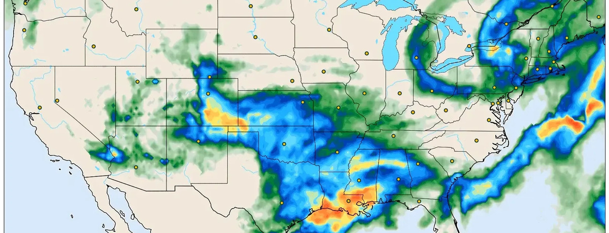
A powerful frontal system is sweeping across the United States today, Thursday, May 8, 2025, unleashing widespread heavy rain, thunderstorms, and local flood risks. Based on the ICON Global model forecast (+45h from May 6 12 UTC), intense rainfall bands are expected to impact the southern and eastern states the most, with localized totals exceeding 100 mm (4 inches).
🌎 Regional Forecast – Where It Will Rain the Most
Southern U.S. (Texas, Louisiana, Mississippi, Alabama)
A major rain corridor will strike the Gulf Coast and lower Mississippi Valley. Cities like Houston, Baton Rouge, and New Orleans are facing intense rainfall from early morning into the evening. Downpours may exceed 100 mm and could lead to flash flooding. Thunderstorms are also likely, especially during the late morning to afternoon hours.
Central Plains (Oklahoma, Arkansas, Missouri)
Expect modera to heavy rainfall between late morning and early evening. Precipitation totals may reach 30–80 mm. Road conditions may worsen, and isolated thunderstorm activity is possible.
Northeast (New York, Pennsylvania, New England)
Moisture-laden air from the south will surge into the region by afternoon and evening. Rain will intensify through the evening hours with possible embedded thunderstorms. While totals are lower than the South, urban flooding in areas like New York City is not out of the question.
Southwest (New Mexico, Arizona)
Scattered storms will form across the region with locally heavy rain. These are brief but intense and may lead to wind gusts and sudden downpours, especially in elevated terrain.
🕐 Hour-by-Hour Weather Highlights (local time summaries)
Early Morning (6:00–9:00)
Rain will already be active over southeast Texas and Louisiana. Light showers may begin forming as far north as the Ohio Valley.
Midday (12:00–15:00)
This is the peak rainfall window for Texas, Louisiana, Mississippi, and Arkansas. Thunderstorms likely develop, with chances of lightning, strong winds, and poor visibility on roads.
Afternoon to Evening (15:00–21:00)
Rain shifts eastward into Alabama, Georgia, and the Carolinas. Meanwhile, the Northeast enters the risk zone with heavier rain moving toward Pennsylvania and New York. Expect growing travel delays by evening rush hour.
Night (21:00–midnight)
Rain continues along the Eastern Saboard while weakening slightly in the South. Cloud cover and damp conditions remain widespread.
🧥 What to Wear?
-
Gulf Coast and Southeast: Waterproof jacket, umbrella, and water-resistant boots are essential. Storm-proof outerwear is recommended for those spending time outdoors.
-
Central and Northeast: Layered clothing with a light rain jacket. Avoid cotton, as it stays wet longer.
-
Southwest: Lightweight but wind-resistant attire with quick-dry materials in case of sudden storms.
⚠️ Weather Alerts and Hazards
-
Flash Flood Watches are in effect across southeastern Texas and southern Louisiana.
-
Severe Thunderstorm Risk includes parts of Mississippi, Georgia, and eastern Arkansas with potential wind gusts over 70 km/h (45 mph).
-
Travel Disruptions expected in cities like New York, Philadelphia, Atlanta, and Dallas due to wet runways, traffic slowdowns, and possible delays in public transport.
![]()
🌐 Forecast based on ICON Global model run by LeoMeteo – Valid May 8, 2025 at 09:00 UTC
Stay informed via LEOMeteo.com/model/icon for real-time updates.